Monday, January 31, 2011

Krause Horizon Variations and Golden Section

Exercise 1
Point Placement
The first exercise was to use the Principle of Unequal Spacing to place points on a piece of graph paper. Krause says to use this principle and apply it to “points-of-interest” in later compositions. Placing various focal points in random spaces of compositions ensures that the work will be more pleasing to the eye.

Exercise 2
Horizon Variations
The second exercise dealt with cropping photos in order to alter the positioning of the horizon. Krause says to avoid centering the horizon line in an image unless it is for a certain reason.

In the first original image, there is a lot going on with the cars, trees, and telephone poles. We were told to crop the photo in order to draw a stronger focus on the road as opposed to the sky. 
Original Image 1
The image below is my edited version of the horizon photo. I used the crop tool in order to cut out as much of the sky as possible. I tried to cut off some of the tops of the telephone poles. I also made sure to follow Krause’s advice by placing the horizon higher rather than in the center of the image.
Focus on Road
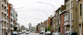
In the second original image, the horizon is placed directly in the center of the image and the intended focus is unclear.
Original Image 2
The image below is my edited version of the second horizon photo. I used the crop tool in order to place more of a focus on the skyline. I also cut out a piece of the buildings on the left because I found the ones on the right to be more aesthetically pleasing.
Focus on Sky
I believe that my cropped images are much more pleasing to the eye and effectively show how the focus of an image may be changed using the crop tool.

Exercise 3 
Golden Section Ruler


Krause explains the Golden Section as “an aesthetically pleasing division of space that is often used by artists as the basis for measurements within their compositions” (34). To the left is my Golden Section Ruler. I created a new canvas in Photoshop and then using the rectangle tool I drew a 13” long. I then divided the ruler in two sections, one 8” and one 5”. I separated the two by using the paint bucket tool and coloring one purple and the other pink. I will be able to insert this ruler into Photoshop as a layer in order to determine where to place focal points in future compositions.

Wednesday, January 19, 2011

Google Earth & Geospatial Projects Event

Mapping Historical Resources, Harrisonburg, VA, Kevin Borg, History Dept.
Professor Borg began by passing around a map of Harrisonburg. The representational graphic allowed the audience to see the types of maps Borg and his students worked with. Borg and his students scanned sections of maps drawn in 1912. Borg then used Google Earth Pro to piece together the maps of 1912. He then overlapped this now complete map on top of the Google Earth images of Harrisonburg. This allows students and citizens of Harrisonburg to compare what the town used to consist of versus what it consists of today. The visuals were very helpful. The images of Harrisonburg today were very recognizable because they were full colored pictures. It was difficult to truly picture what Harrisonburg looked like in 1912 because it was only represented by line drawings that mapped out infrastructures of the town. However, Borg did mention that he hoped to receive grant money that would allow him access to colored images of Harrisonburg in 1912. The visuals Borg used helped change the audiences perspective of the subject because people do not often walk around a town thinking of what it used to look like. Instead, we only focus on today. It was interesting to see into the past of Harrisonburg and to realize how it has developed. The graphics were presented using a projector and screen. This equipment may have effected the images due to the screen resolution and how many pixels the projector lens presents. Borg did a good job of expressing how the process was for him and his students and made it possible for the audience to understand the struggles the students went through without actually hearing from them. Borg used a few terms that I was not aware of before this presentation. First, I learned that "Art GIS" is a map making program. Then, I learned the technique "rubber sheeting", where one looks for anything that exists on maps now that had also existed in the past (as in 1912). Also, I learned that "geotips" are tip files that have the location (longitude and latitude) embedded in them.


Interactive Geologic Maps of Virginia and the Shenandoah Valley Region, Steve Whitmeyer, Geology & Environmental Science Dept.
Steve Whitmeyer used representational graphics to discuss the geological make up of Virginia. He used Google Earth  Pro to show the audience maps, cross sections, and actual photographs of the different types of rocks that make up the land in the Virginia area. Whitmeyer said that he hoped to create a geological template for Virginia and, if successful, would use the template for other areas of the world as well. He aimed to help citizens have a better understanding of the regional development of Virginia as a whole. This presentation seemed to be more technical and was mostly aimed towards those with a general understanding of geology. It was helpful that Whitmeyer used several different types of graphics. He did the presentation in layers. Whitmeyer began by showing an image of Virginia. He then zoomed in and the map separated the different regions of Virginia into different colors. As he zoomed closer and closer the images became more detailed. They started to show the types of rocks in the region and the different elevations of the land. Whitmeyer had also embedded links to photos of different areas to help the audience picture exactly what area was being discussed. Whitmeyer used a projector and screen. The equipment may have affected the image clarity due to the screen resolution and number of pixels the projector lens presented. It would have been helpful to see images of other geological maps to compare the similarities and differences between them and Whitmeyer's. It was difficult to follow this presentation at points because I am unaware of geological terms. Whitmeyer did not express why this template would be helpful to citizens of Harrisonburg and/or Virginia as a whole.